California’s coastline has already experienced a troubling preview of what this winter could bring. In late October, unusually high ocean levels pushed seawater into coastal neighborhoods, damaged 114 homes and other structures in Huntington Beach, and flooded parts of Pacific Coast Highway. Restaurants and beachside businesses from Redondo Beach to Long Beach were also affected. Yet the tides responsible for the flooding were not even the highest expected this year.
That is what makes the coming months particularly concerning. The Pacific Ocean is unusually warm, raising sea levels along the California coast. Some of the highest astronomical tides of the year are approaching, and winter storms could add powerful waves to an already elevated ocean. If these conditions occur at the same time, coastal communities could face substantially more severe flooding.
The recent damage was caused by more than an ordinary high tide. Warm ocean water had already pushed sea levels above their usual range, leaving less room for tides and waves before seawater reached streets, buildings and other coastal infrastructure. With El Niño developing in the Pacific, scientists warn that the conditions behind the flooding may persist through the winter.
Record-High Ocean Levels Have Already Hit California
The measurements from late October show how unusual the situation has become. An analysis of data provided by William Sweet, an oceanographer with the National Oceanic and Atmospheric Administration, found that average sea levels during the week ending Friday were 1.4 feet above expected levels in San Diego, 1.3 feet higher in Los Angeles and 1.1 feet higher in San Francisco.
Several locations recorded maximum water levels not seen in more than a century of observations. At the San Pedro gauge in Los Angeles, the water reached 8.02 feet on October 26 before climbing to 8.19 feet the following day. Both readings broke the previous record of 7.93 feet, established on January 10, 2005, during an El Niño winter. Records were also broken in San Diego Bay, Santa Barbara and La Jolla.
The consequences were already visible in coastal communities. Huntington Beach reported damage to 114 homes and other structures, mostly in Sunset Beach and Huntington Harbour. Seawater also flooded parts of Pacific Coast Highway. Farther north, bayside communities in Marin County experienced flooding of up to two feet, according to state officials.
Despite the record water levels, the late-October tides were not king tides. UC Agriculture and Natural Resources climate scientist Daniel Swain explained that the flooding was driven primarily by extraordinary increases in ocean levels, rather than an unusually strong alignment of the sun and moon. The distinction is important because even higher astronomical tides are expected later in November and December.
How El Niño and Kelvin Waves Are Raising Sea Levels
One of the main contributors to the elevated water is the Pacific’s unusually high temperature. As seawater warms, it expands and takes up more space, a process known as thermal expansion. When large areas of the ocean remain warmer than normal, this expansion can contribute to higher sea levels along nearby coastlines.
The water off Southern California has been exceptionally warm. On Halloween, October 31, the sea surface temperature at Scripps Pier in La Jolla reached 75.4 degrees Fahrenheit. That was 11.1 degrees above the historical average for the date and broke the Halloween temperature record in measurements dating back to 1916. It was also warmer than the location’s highest average sea surface temperature for an entire year, which is around 70 degrees.
Scientists expect ocean temperatures to remain above normal through much of the winter and potentially into the spring. Dillon Amaya, an assistant professor in North Carolina State University’s Department of Marine, Earth and Atmospheric Sciences, said the approaching king tides could provide a stronger trigger for flooding. He also expects the ocean to remain warmer than average for at least several more months.
Another important part of the developing El Niño is the movement of oceanic Kelvin waves. These waves carry warm water thousands of miles across the Pacific, from the western part of the ocean toward the eastern Pacific near South America. When they reach the coast of the Americas, they move along the shoreline, contributing to warmer ocean temperatures and higher sea levels. Their effects can last for months.
Meteorologist Robbie Munroe of the National Weather Service office in Oxnard said water levels along the California coast have been roughly one to one-and-a-half feet higher than normal because of warm water and Kelvin waves. NOAA’s National Ocean Service has also identified these waves as a contributor to newly broken water-level records along the California coast.
The latest Kelvin wave appears to have moved along Southern California around the time of the late-October flooding. According to Amaya, the resulting increase in some locations has brought water levels close to two feet above what would normally be expected from astronomical tides alone. That additional water helps explain why even tides that were not at their seasonal peak caused such extensive problems.
The Next King Tides Could Bring Greater Flooding
California is approaching a period when astronomical tides will reach some of their highest levels. Two long-term lunar cycles influence these tides: an 18.6-year cycle involving the moon’s orbital nodes and a 4.4-year cycle linked to lunar perigee. Small changes in the moon’s orbit affect the gravitational forces that influence tidal movement.
Reinhard Flick, a researcher at the Scripps Institution of Oceanography at UC San Diego, said these cycles are contributing to unusually high tides expected later this year. In La Jolla, an astronomical high tide of seven feet or more above the established baseline is relatively rare over a century of observations. However, forecasts indicate that tides at or above that level could occur on November 25, the day before Thanksgiving, and again on December 23, 24 and 25.
Those forecasts account for astronomical tides, but they do not include the additional rise caused by unusually warm ocean water. If the Pacific remains elevated, the actual water levels reaching the coast could exceed what tide predictions alone suggest.
This is why the next several weeks matter. The late-October flooding occurred before the highest astronomical tides arrived. The upcoming tides will take place while the ocean is still unusually warm, potentially creating a more dangerous combination for communities that have already experienced damage.
Winter Storms Could Add Powerful Waves to the Threat
High tides and warmer water are not the only concerns. Winter storms can generate large swells that push additional water toward the shore, increasing the risk of flooding and coastal erosion.
Southern California’s south-facing beaches have experienced much of the recent impact, but meteorologists expect wave directions to change as winter storms develop. Munroe said swells could increasingly arrive from the northwest or southwest, depending on the orientation of the storms.
There has already been an example of how powerful waves can affect coastal neighborhoods under elevated ocean conditions. In early October, swells from former Hurricane Rachel sent seawater crashing into homes on the Long Beach Peninsula and covered parts of Newport Beach’s Balboa Peninsula.
If similar waves arrive during unusually high tides, the consequences could extend beyond beachfront properties. Roads, restaurants, residential neighborhoods and other infrastructure close to the water may face repeated flooding. The exact impact will depend on the location, wave direction, timing of the tides and how high sea levels remain.
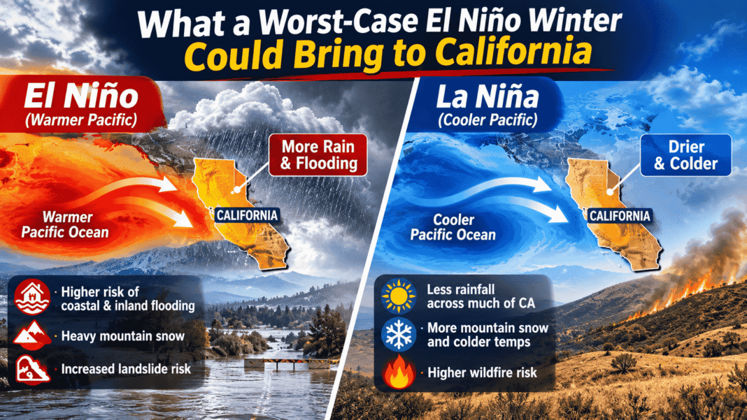
The National Weather Service considers coastal flooding one of the more certain risks associated with El Niño in California later this year. Federal scientists have also estimated an 83% chance that the developing event will become the strongest El Niño in the modern record, which dates to 1950. That is a forecast, not a guarantee, but it adds to concerns about the strength of the developing climate pattern.
California’s Latest Flooding Offers a Warning About Rising Seas
The immediate threat is tied to El Niño and unusually warm ocean conditions, but California’s coastal vulnerability extends beyond this winter. The state has already experienced an estimated eight to 12 inches of background sea-level rise, according to Amaya. A 2024 California sea-level rise assessment estimated that Los Angeles could see more than one additional foot of sea-level rise between 2000 and 2070 under an intermediate scenario. Under a high scenario, the increase could approach three feet.
El Niño can temporarily intensify the effects of that longer-term rise. Oceanographer William Sweet explained that powerful Kelvin waves can bring decades’ worth of sea-level rise to the California coast over a much shorter period. The increase is temporary, but it can still produce serious erosion and flooding while it lasts.
The effects of the unusually warm Pacific are also being felt inland. On November 1, extreme rainfall triggered flash flooding and evacuations across parts of Arizona and the Four Corners region, which includes New Mexico, Utah and Colorado. Climate scientist Daniel Swain linked the large amount of atmospheric moisture partly to an exceptional marine heat wave along the Baja California coast, which is associated with both the developing El Niño and climate change.
For California’s coastal communities, the immediate concern is the combination of conditions expected in the weeks ahead. The ocean is already unusually high, the next major tides are approaching, and winter storms could bring large waves. The flooding in October showed that serious damage can occur even before the year’s highest tides arrive. The next few months will reveal how much more pressure the coastline can withstand.